

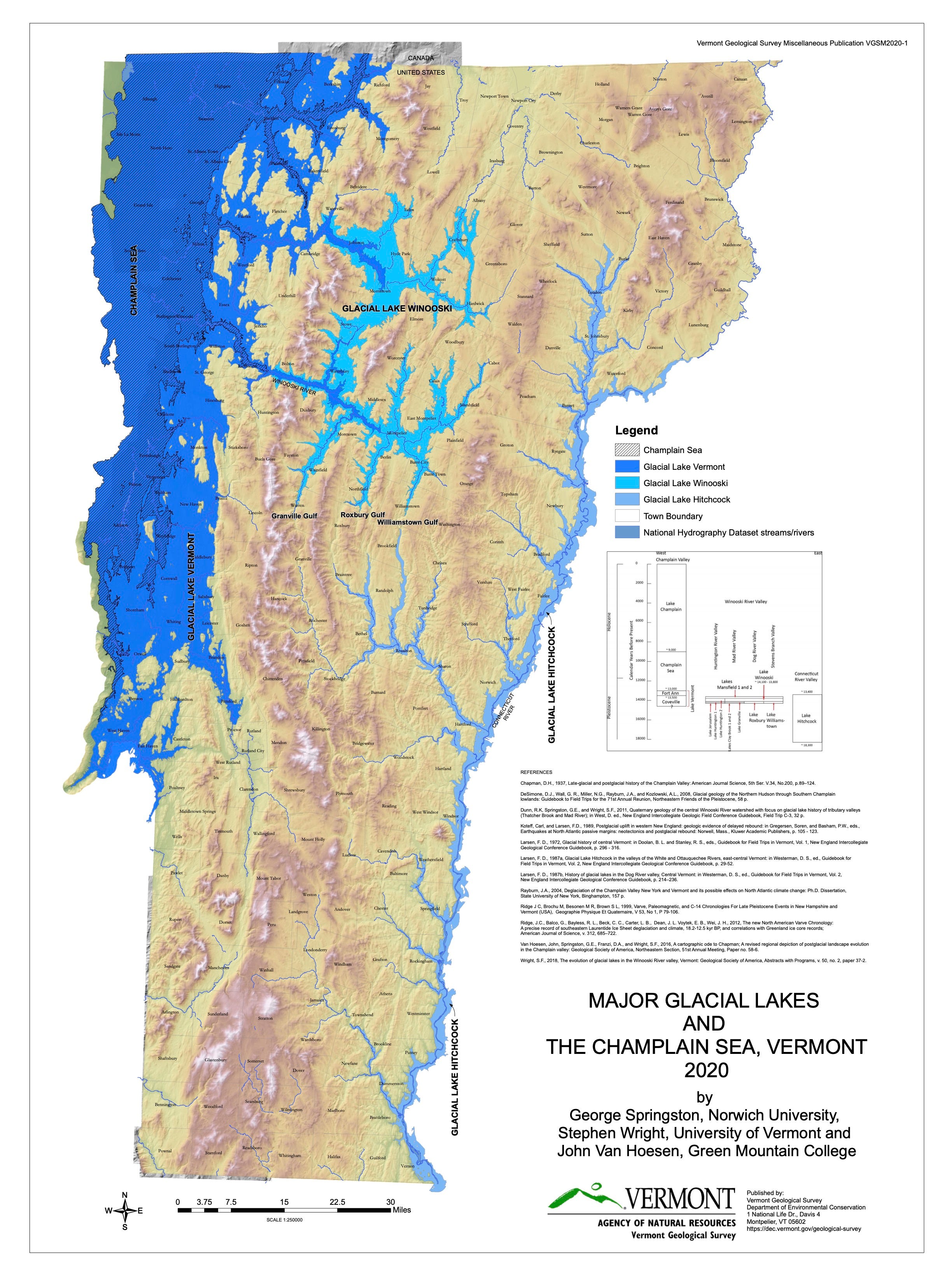
Here’s this week’s jigsaw: Glacial Lakes and the Champlain Sea
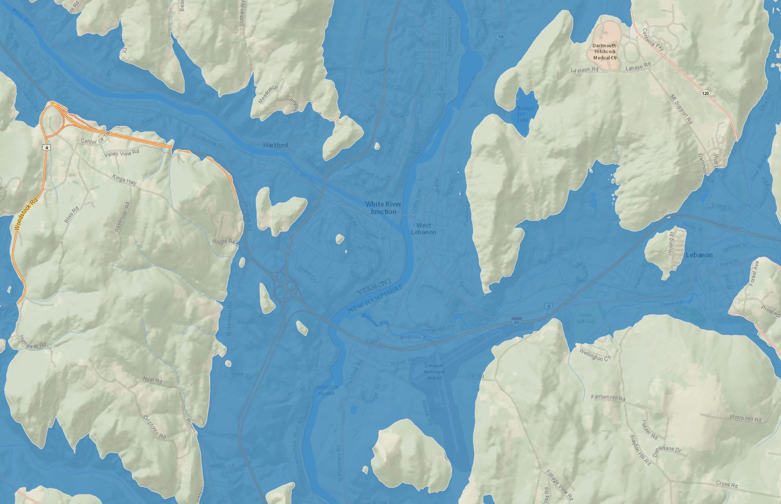
The map above makes the best jigsaw puzzle, but this map is better for exploring: it’s interactive, with towns, roads, and other features labeled. You can zoom into your neighborhood to see if you were part of Lake Hitchcock some 12,000 years ago. Bible literalists will quibble.
The example below covers the Hartford-to-Lebanon area. The high water mark for Lake Hitchcock is figured to be 720 feet above sea level.
A 1935 article in the Dartmouth Alumni Magazine has a nice piece mentioning a handy landmark to note when imagining being underwater:
”The water line at an elevation of 657 feet would have stood 112 feet above the center of the campus so that only that part of the Baker Library tower above the middle of the clock face and the uppermost twelve feet of stonework on the College Tower would have projected above the water.”
A short summary of Lake Hitchcock
During the height of the last glacial advance, the Laurentide Ice Sheet covered Vermont and the surrounding region with ice up to a mile thick for tens of thousands of years.
About 15,000 years ago, as the Laurentide Ice Sheet began its retreat northward, meltwaters collecting behind a terminal moraine that dammed the Connecticut River Valley.
This created a long, narrow glacial lake now called Lake Hitchcock. At its greatest extent it stretched from what is now northern Vermont down into Connecticut (~200–320 miles) and existed in its major form for about 3,000 to 4,000 years. At its height, the lake even pushed up its tributaries, flooding valleys as far inland as Woodstock, West Fairlee, and Brookfield.
The lake held silt and clay layers (varves) in annual deposit rhythms that scientists today still study for clues about deglaciation. When the dam‑moraine eroded or breached, the lake drained in stages, leaving behind the fertile valley floor, the modern river corridor, and geological evidence everywhere.
The video below is great for showing examples from the present-day Connecticut River Valley:
The video below is an excellent and informative video, with geological details. Thanks to Greg Stott, Hanover Richmond School teacher.
“You really have to imagine a place that’s nothing like we see it today…oceans on both sides and a giant glacial lake splitting the region down the middle.”
Sources:
https://en.wikipedia.org/wiki/Lake_Hitchcock
https://en.wikipedia.org/wiki/Champlain_Sea
https://earthathome.org/hoe/ne/glaciers/
https://vtdigger.org/2021/10/03/then-again-vermont-spent-70000-years-under-ice-about-a-mile-thick/
https://kids.kiddle.co/Lake_Hitchcock
https://varves.as.tufts.edu/NAVC/navcconnvalley.asp
https://archive.dartmouthalumnimagazine.com/article/1935/5/1/hanover-submerged
https://maps.app.goo.gl/Je25F8U4YpmdyfnY8
Thanks for reading, and please support your local and state historical societies.
Cameron Cross
The Curioustorian
Enjoy this puzzle and article?
Get one each weekend by signing up for my weekly email.
All of your posts are fascinating. This Lake Hitchcock was especially so. Having lived around the Connecticut River for 70 years I have noticed some areas of varved layers mostly along the course of the White River. Please Keep up the fascinating posts.
I love this! I am a GLH enthusiast. Would like to connect with you. My GLH doc is on YouTube at https://youtube.com/@gregstott7507?si=kNQXNGKPi2fT7E26