

Jigsaw for October 10, 2026: the Junction House block on the 1917 map
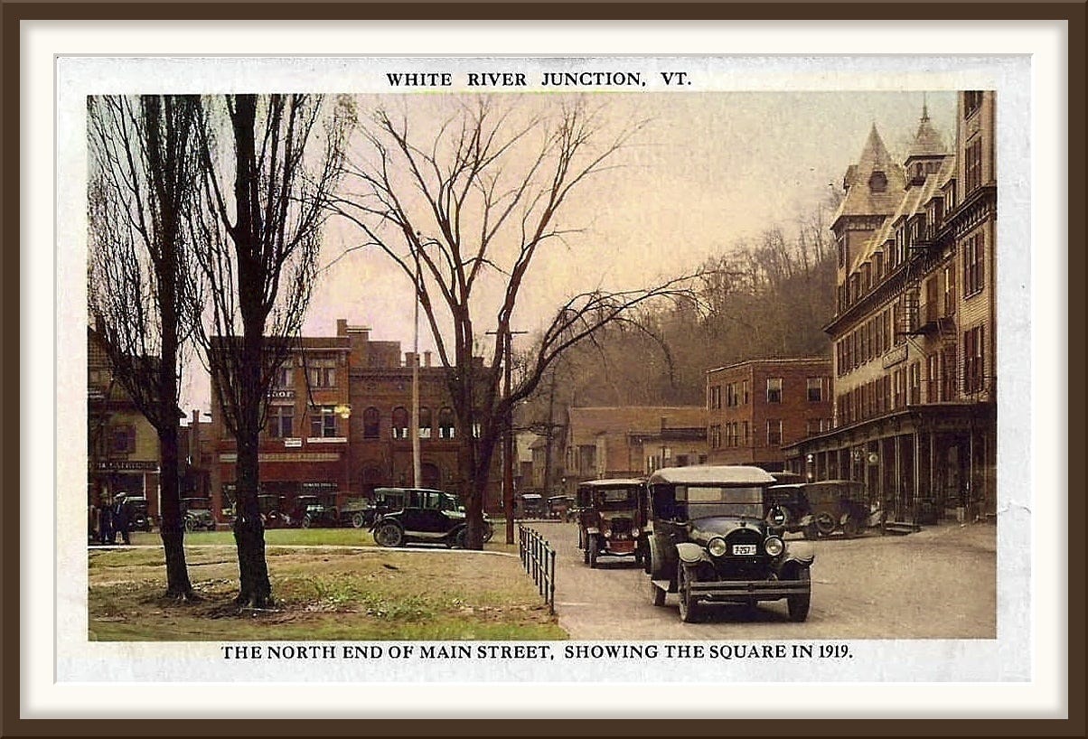
A few weeks ago we stood on the Square in White River Junction and looked south down Main Street at a row of storefronts, and I could tell you almost nothing about them.
Two documents name most of them.
The first document tells you what the buildings are
In 2018 the White River Junction Historic District nomination to the National Register of Historic Places was updated. It includes an inventory of 85 buildings, each with a name, a street address, a construction date, and a note on whether it still contributes to the district’s character.
The tall building on the right of that photograph is resource number 17, the Hotel Coolidge, 39 South Main Street, 1925 to 1926. And because the inventory also describes what stood there before, we know the building actually in the picture was the 1879 Junction House, with a porch across its whole front and corner towers under steep pyramidal roofs.
The second document tells you who was inside them
The nomination does not list the businesses inside. For those we turn to the Sanborn fire insurance maps.
From the 1860s onward the Sanborn Map Company surveyed American towns for fire insurance underwriters. An underwriter in Boston needed to know, without traveling, what a building in Vermont was made of, how many stories it had, whether it kept a boiler or a skylight or a store of kerosene, and what stood close enough to carry a fire across to it. So Sanborn's surveyors walked the streets and drew everything.
The colors are the code. Yellow means wood frame, pink means brick, blue means stone or concrete, and the numbers give the stories. And because the underwriter needed to know what was burning, the surveyors wrote the occupant into the footprint: grocery, harness, millinery, dentist, billiards, bakery.
A short key to the rest. D is a dwelling, D.G. dry goods, B & S boots and shoes, Clo. clothing, Gro. grocery, Milly a milliner, Restrt. a restaurant and Off. an office. A red circle marked F.A. is a fire alarm box, and D.H. is a double hydrant. A small x in the corner of a building means a shingle roof. The numbers along the street are house numbers.
Drawn for insurance clerks, the maps also recorded who was in each storefront, edition after edition.
White River Junction was surveyed in 1894, 1901, 1906, 1917, 1925 and 1941. The Library of Congress has digitized the first four, free to use.
What the 1917 map says about our street
Here is the postcard again.
Everything below comes from two sheets of the June 1917 survey, drawn two years before the picture. I name a building only where the map, the nomination and the photograph all agree.
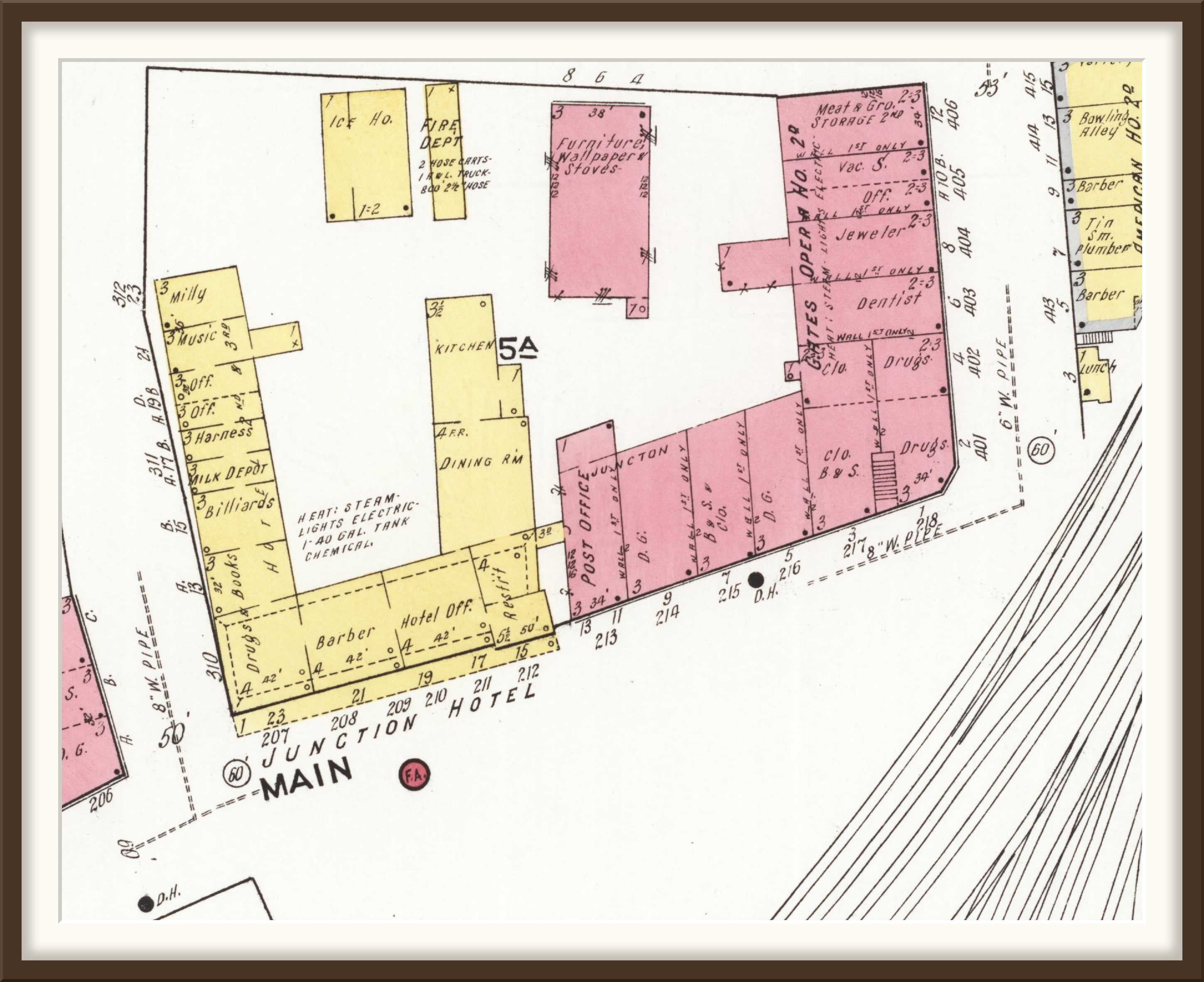
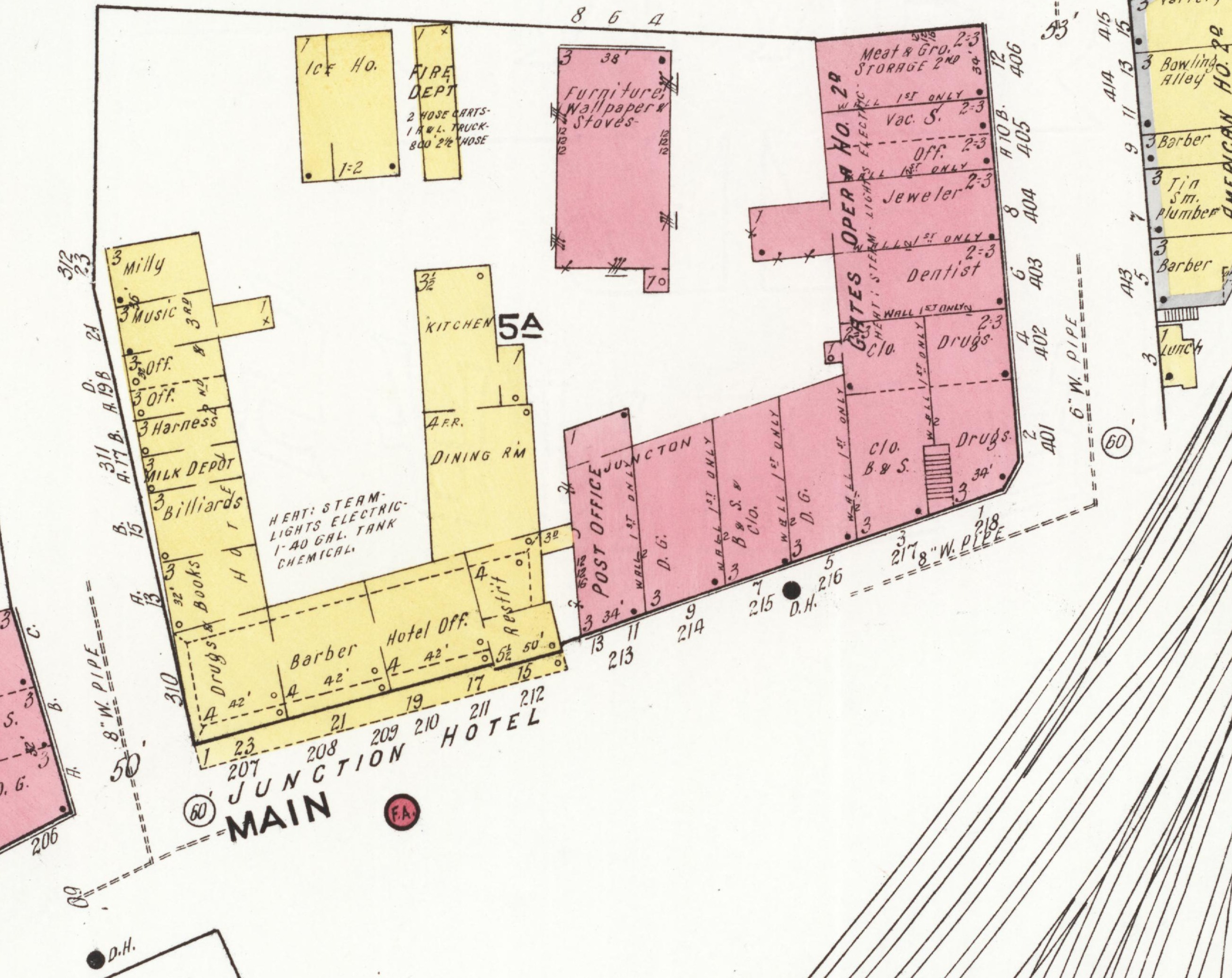
Start on the right, with the hotel. The map at the top of this post prints “JUNCTION HOTEL” across its front and colors it yellow, wood, four stories. Under that long porch it lists a barber, the hotel office and a restaurant. Around the corner on Gates Street, out of sight, ran a row of small shops: drugs, books, billiards, a milk depot, a harness maker, a music store and a milliner. The kitchen and the dining room filled the back.
A 1903 write-up of the hotel praised its billiards room and its barber shop. Fourteen years later the surveyor found both. Across the middle of the building he wrote what the underwriter most wanted to know: “Heat: steam. Lights electric. 1-40 gal. tank chemical.” That is a forty-gallon chemical fire extinguisher.
One tenant came too late for the map. In 1918 Calman Colodny opened his Surprise Store in the Junction House, so it was in there somewhere when this picture was taken. The Surprise Store stayed in the Colodny family until 1991.
Past the hotel’s far tower, across Gates Street, stands a brick block, pink on the map and three stories high. The map puts a grocery, a boot and shoe store and a dry goods store in it.
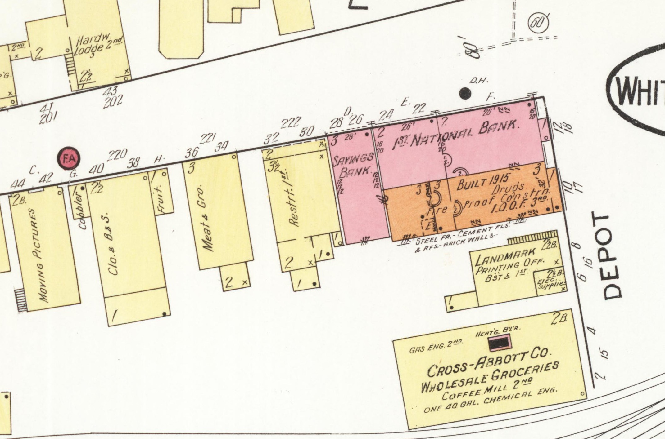
Now the left side. The brick building with the round-arched windows is the First National Bank, built in 1892. The map puts it at the corner of Main and Depot Street. We call that stretch Gates Street now, which is why the nomination gives the bank’s address as 28 Gates Street.
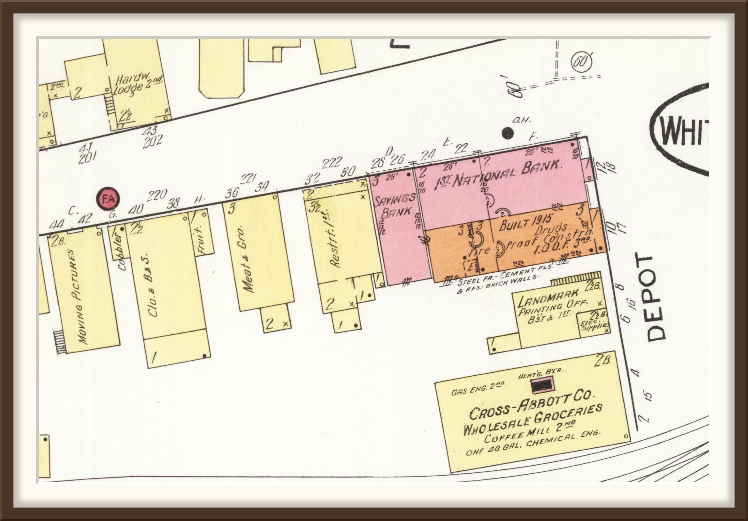
The map shows two additions behind it. The White River Savings Bank had the Main Street side. The other wing is orange, a color of its own, and the surveyor spelled out why: “Built 1915. Drugs. Fire proof constrn. I.O.O.F. 3rd.” The nomination, written a century later, says the 1915 wing went up for the Howard Drug Company and the Odd Fellows.
The bank is still there, arches and all, but you cannot see it from where our photographer stood. In 1934 the government built a post office on the Square, right in front of it. The bank objected. It lost its view of the street and its easy access for automobiles.
Beyond the bank, the map lines the east side of Main with wooden buildings: a restaurant, a meat and grocery, a fruit stand, clothing and shoes, a cobbler, and a moving picture house. On the postcard they are a row of rooftops. Here the map does the seeing.
And behind you, out of the picture, is the Gates Block of 1890. The map fills it with dry goods, clothing, drugs, a dentist and a jeweler, with the Gates Opera House upstairs. It also held the post office, from 1890 until the new one went up in front of the bank.
Cross-Abbott
The wholesale grocery at 2 to 4 Gates Street was built in 1894 by Charles A. Cross and Charles C. Abbott, on land leased from the Vermont Central. Cross-Abbott dealt in groceries and nothing else, and it was one of thirteen (!) wholesale houses working out of this village by 1903. They joined the Red and White Corporation in 1948 and moved out in 1957, and White River Paper took the building over.
Today it is Vermont Salvage.
The map shows it just behind the bank: “Cross-Abbott Co. Wholesale Groceries. Coffee mill 2nd.”
What the map cannot do
The postcard is about a thousand pixels across, and I have found no larger copy. Enlarged, its signs blur past reading.
That matters, because the signs are the one source that would confirm the map rather than merely agree with it. Other photographs of the village are four and six thousand pixels across, and their signs can be read.
A larger scan of the original postcard would settle it.
Full-resolution images
The Junction House block, 1917 Sanborn map, sheet 2
The First National Bank corner, 1917 Sanborn map, sheet 3
More from White River Junction


A word of thanks
To the Library of Congress, for scanning the Sanborn sheets and putting them online for anyone to read. And to the people who prepared the 2018 update of the White River Junction Historic District nomination, whose inventory let me put names to these buildings.
Thanks for your support, as always,
Cameron Cross
Sources
Sanborn Fire Insurance Maps, White River Junction, Vermont, all editions, Library of Congress
The Gateway of Vermont: Hartford and its Villages, 1903, the hotel description, Internet Archive
Cross-Abbott and Vermont Salvage historical marker, 14 Gates Street, Historical Marker Database